
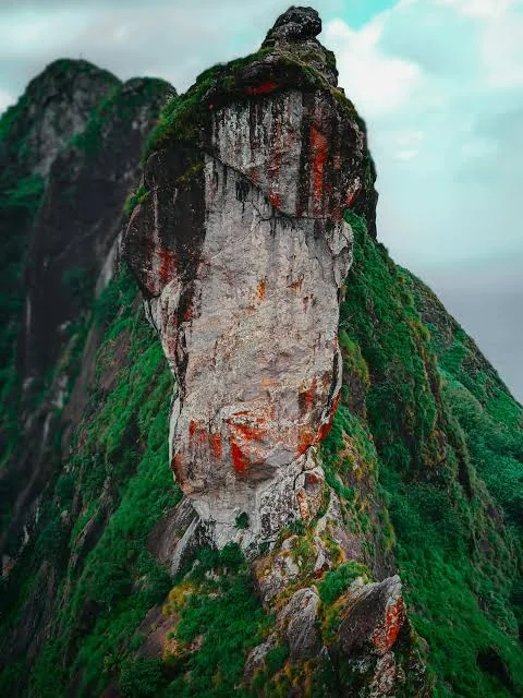
Illikkal Kallu is a striking hill attraction in the Melukavu area of Kottayam district, Kerala. The destination is known for its dramatic rock formations, steep slopes and wide views across the Western Ghats. Three prominent rock formations make up the Illikkal Kallu landscape, including Kuda Kallu, which resembles an umbrella, and Koonu Kallu, whose shape suggests a hunched figure. A narrow rock formation known as Narakapalam is another feature associated with the hill.
The climb and viewpoint experience are a major part of a visit to Illikkal Kallu. On clear days, the elevated position offers views of the surrounding valleys and distant landscape. Mist and changing cloud cover can give the hill a very different appearance throughout the day, while the monsoon brings fresh greenery and more challenging weather conditions.
For travellers searching for Illikkal Kallu in Kottayam, hill stations near Kottayam or scenic viewpoints in Kerala, this destination offers a memorable mountain outing. Access involves steep and exposed terrain, so visitors should use designated paths, follow local instructions and avoid approaching cliff edges. Check road conditions, entry arrangements and weather updates before travelling, particularly during heavy rain or strong winds.
Illikkal Kallu is located in the Melukavu region of Kottayam district, Kerala, in the Western Ghats. It is a popular hill destination for travellers exploring eastern Kottayam.
Illikkal Kallu is famous for its unusual rock formations, including Kuda Kallu and Koonu Kallu, as well as its elevated views of the surrounding hills and valleys.
Kuda Kallu is a rock formation shaped somewhat like an umbrella, while Koonu Kallu has a hunched appearance. Both are distinctive features of the Illikkal Kallu hill landscape.
Narakapalam is the name given to a narrow rock formation associated with the Illikkal Kallu viewpoint. Visitors should admire it from permitted areas and avoid unsafe crossings.
Clear-weather days are generally better for panoramic views. The monsoon brings mist and greenery but can also create slippery paths, poor visibility and difficult road conditions.
Visitors may need to walk along designated paths to reach viewpoints. The terrain can be steep and exposed, so follow local access instructions and wear suitable footwear.
It can be included in a family sightseeing plan, but steep slopes and exposed viewpoints require care. Keep children close and avoid approaching cliff edges.
Ilaveezhapoonchira, Marmala Waterfalls, Kattikkayam Waterfalls and Vagamon are among the destinations that can be considered for a wider Kottayam–Idukki hill trip.
Ilaveezhapoonchira is a scenic hill destination near Melukavu in Kottayam district, Kerala. Surrounded by three hills—Mankunnu, Kudayathoormala and Thonippara—the area is known for its open grasslands, rocky slopes and broad valley views. Unlike forest-covered hill stations, much of Ilaveezhapoonchira has an open landscape, allowing visitors to enjoy uninterrupted views of the surrounding highlands.
The name Ilaveezhapoonchira is commonly explained as a valley where leaves do not fall, reflecting the area's relatively treeless terrain. During the monsoon, rainwater collects across parts of the valley, creating a seasonal lake-like landscape. The destination is also popular for sunrise and sunset views, although visibility depends on cloud cover and weather.
Local tradition connects Ilaveezhapoonchira with the Pandavas and Draupadi from the Mahabharata. This is a regional legend rather than a verified historical account. Visitors can explore the viewpoints and permitted walking routes, or arrange an authorised jeep ride where available. Travellers searching for Ilaveezhapoonchira in Kottayam, hill viewpoints near Kottayam and trekking destinations in Kerala should check current access conditions before travelling. The terrain can become slippery during rain, so suitable footwear and caution are important.
Ilaveezhapoonchira is located near Melukavu in Kottayam district, Kerala. It is surrounded by the hills of Mankunnu, Kudayathoormala and Thonippara.
Ilaveezhapoonchira is known for its open valleys, rolling hills, seasonal monsoon water, trekking routes and sunrise and sunset viewpoints.
The name is commonly interpreted as a valley or pond where leaves do not fall. It refers to the open, largely treeless character of the landscape.
Yes. Ilaveezhapoonchira is known as a sunrise and sunset viewpoint. Arrive with enough time and check access rules, weather and visibility before travelling.
Parts of the valley collect rainwater during the monsoon, creating a seasonal lake-like appearance. The extent of water coverage varies with rainfall.
The hills have walking and trekking routes, and visitors may find guided or authorised jeep access depending on current arrangements. Confirm permitted routes locally.
Clear days are preferable for distant views. The monsoon creates a distinctive green landscape, but rain can bring slippery ground, mist and reduced visibility.
Illikkal Kallu, Ayyampara Hills, Marmala Waterfalls and Kattikkayam Waterfalls are among the nearby hill and nature attractions to consider.
Vagamon is a popular hill station in Kerala, located along the Kottayam–Idukki border in the Western Ghats. The destination is known for its rolling grasslands, tea plantations, pine forests and mist-covered valleys. Although closely associated with Kottayam tourism, Vagamon is administratively in Idukki district, making it a useful stop for travellers exploring both districts.
The landscape includes well-known attractions such as Vagamon Meadows, Pine Valley, Kurisumala, Thangalpara and Murugan Hill. These places give the hill station a mix of nature, outdoor recreation and religious significance. The three hills—Thangal Hill, Murugan Hill and Kurisumala—are associated with Muslim, Hindu and Christian traditions respectively, reflecting the area's diverse pilgrimage heritage.
Vagamon also attracts visitors interested in trekking, cycling, paragliding and scenic drives. Activity availability depends on weather, authorised operators and seasonal schedules. The pine forest and grassy hills are popular photography locations, while the surrounding tea estates provide a glimpse of the region's plantation landscape. Travellers searching for Vagamon hill station in Kerala, Vagamon tourist places or hill stations near Kottayam can plan a full-day visit or overnight stay. Check current activity permissions and weather conditions before setting out.
Vagamon is located on the Kottayam–Idukki border in Kerala and is administratively part of Idukki district. It is accessible from Kottayam and other towns in central Kerala.
Vagamon is famous for its green meadows, pine forests, tea plantations, misty hills, viewpoints and outdoor activities such as trekking and paragliding.
Vagamon is situated near the border of Kottayam and Idukki, but it is administratively in Idukki district. It is commonly included in Kottayam-region travel itineraries.
Popular attractions include Vagamon Meadows, Pine Valley, Kurisumala, Thangalpara, Murugan Hill and nearby viewpoints. Access and activity availability can vary.
Paragliding has been offered in Vagamon through organised operators and events. It is subject to weather, safety conditions and current operator schedules.
The cooler months from October to March are generally comfortable for sightseeing. The monsoon brings lush greenery and mist but can affect road travel and outdoor activities.
Vagamon is approximately 60–65 km from Kottayam town by road, depending on the route. Travel time varies with traffic and hill-road conditions.
Yes. These destinations can be planned as part of a wider hill trip, but road conditions and walking time should be considered when arranging the route.